


I innlegget nevnes Reaper. Det er en stor drone og noe
helt nytt for Norge. Vi får nå erfaring via vårt engasjement i Eurohawk, og må begynne å tenke stort på våre bredde-
grader også. Eurohawk opererer ut fra Sigonella på Sicilia. (Red.)
California Air Guard Drone Helps Fight Wild Fires
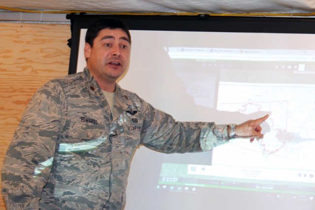
Air Force Maj. Nicholas Edwards, an intelligence analyst manager with the California Air National Guard’s 195th Airlift Wing, updates leaders from the California Department of Forestry and Fire Protection on the Carr Fire in Shasta County, Calif., July 30, 2018. Army photo by Staff Sgt. Edward Siguenza
A team from the California Air National Guard‘s 195th Airlift Wing is being used as a reconnaissance and surveillance unit, providing the state’s Department of Forestry and Fire Protection agency with up-to-date intelligence used to battle current wildfires.
“We’re able to provide real-time eyes on in any area where the fire’s at,” said Air Force Maj. Nicholas Edwards, intelligence analyst manager. “We can provide information to where CAL FIRE can direct resources. We give information to the decision makers in a timely manner.”
Working Together
The California Guard team works side by side with CAL FIRE analysts. In about a week the wildfires have affected nearly 90,000 acres, destroying more than 500 homes and buildings and killing at least six people. Thousands of Redding residents have been evacuated.
The Guard’s contributions are “seriously helping us,” said Capt. Robert DeCamp, CAL FIRE intelligence officer. “The knowledge they have and the information they provide are critical for us to fight the fire. They have equipment we don’t have, and that helps us tremendously.”
Air Force Tech. Sgt. Matthew LeMaire, an imagery expert, and Air Force Staff Sgt. Marlon Ramos, an analyst, monitor the fire via an MQ-9 Reaper, a remotely piloted aircraft. The drone employs its wide-range sensors to collect and send precise data.
Providing Information
Twice daily, LeMaire and Ramos gather the drone’s information and provide printouts to CAL FIRE. The information is transcribed onto maps and other information products and are released to firefighters and emergency crews.
This information is used to track the fire’s movements so authorities can position defenses and notify the public if evacuations are necessary.
“This is one fire that’s very unpredictable, but we can track it with the capabilities the Guard provides us,” DeCamp said.
Ingen kommentarer:
Legg inn en kommentar
Merk: Bare medlemmer av denne bloggen kan legge inn en kommentar.