
IN-FLIGHT PHOTOS SHOW STORM CLOUDS BEFORE FATAL LOCKHART RIVER CRASH
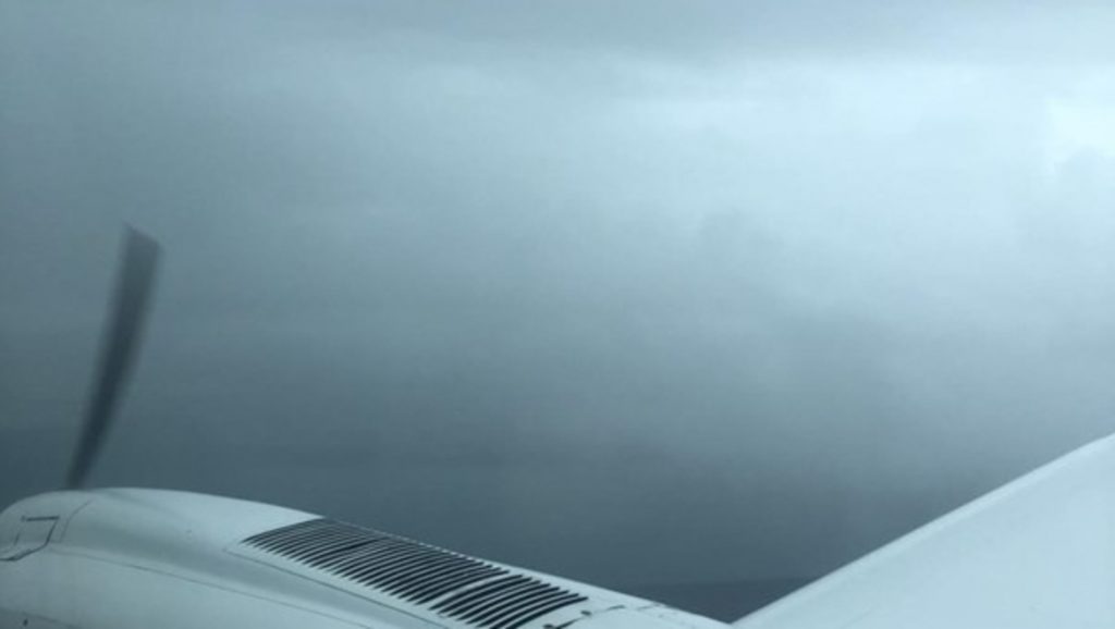
This image was recorded by a passenger on the Cessna looking forward over the right engine and sent via text message at 0903 (ATSB)
A social media post and text message sent by a passenger on a Cessna 404 Titan that subsequently crashed reveals the first attempt at landing was aborted because heavy rain made it impossible to see the runway.
The Air Connect Australia charter, VH-OZO, hit a sand dune on the coast near the Lockhart River, Queensland, on 11 March, killing the pilot and all four passengers.
The images were released as part of an ATSB preliminary investigation into the incident, which also revealed both engines were operating normally. The final report is not expected for months, and the next stage of the process will involve further analysis of recorded flight data and weather conditions.
“There was no evidence of any structural or mechanical defects with the aircraft,” said ATSB executive director of transport safety, Nat Nagy.
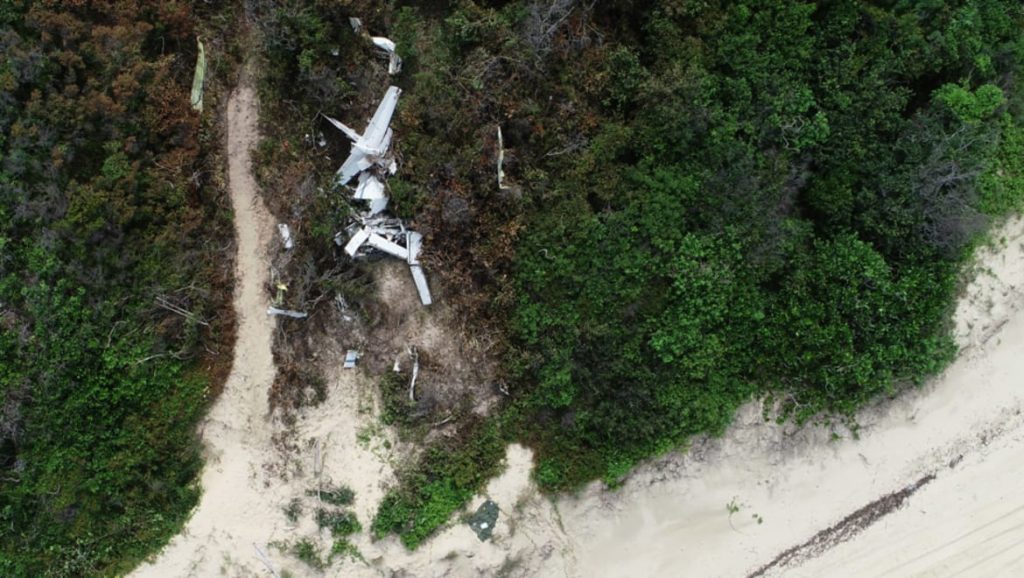
An overview of the accident site, 750 kilometres north of Cairns (ATSB)
The pilot, Stewart Wavill, and four passengers, Henry Roebig, Wayne Brischke, Wayne Ganter and Mark Rawlings, all died when the twin-engine Cessna 404 crashed into a beach east of Lockhart River, about 750 kilometres north of Cairns.
On 11 March 2020, Air Connect Australia was operating a Cessna 404, registered VH-OZO, on a passenger charter flight from Cairns to Lockhart River and back.
The client arranged for the aircraft to depart Cairns at 7:30am with four passengers, wait on the ground at Lockhart River for about five hours, then depart at 2:30pm.
The forecast weather for their arrival at Lockhart River was for overlapping periods of rain and low cloud with possible thunderstorms.
Investigators were able to build an understanding of the aircraft’s flightpath using transmitted GPS data recorded at five-second intervals by an electronic flight bag application on the pilot’s iPad.
That data showed that Wavill was conducting an area navigation (RNAV) GPS instrument approach using track and distance data from satellite navigation receivers to try and land at Lockhart River.
For vertical navigation the pilot was using a combination of altimeter and GPS distance information.
“When the aircraft was about 30 kilometres from Lockhart River, the pilot joined the approach and followed the procedure down to the missed approach waypoint. The pilot continued to track to the runway and operated below the minimum descent altitude (MDA) for a short period until the pilot initiated a missed approach,” Nagy said.
The aircraft climbed to 3,500 feet and tracked for a second GPS approach.
“When flying a GPS approach, the minimum safe altitude progressively steps down between waypoints as the aircraft gets closer to the runway,” said Nagy.
Halfway along the approach, the aircraft descended through the minimum safe altitude of 1,800 feet for that segment.
About 30 seconds after the final approach fix, the data shows the aircraft nearing 700 feet with an apparent decrease in the descent rate for a short period. The aircraft then descended below the minimum descent altitude and diverged to the left, crossing the inbound track at an angle of about 20 degrees.
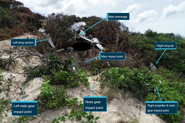
Impact points of VH-OZO and main wreckage, as detailed in the preliminary investigation (ATSB)
“Tragically, the descent continued until the aircraft impacted a sand dune on the coast, fatally injuring all on board,” Nagy said.
Two of the passengers recorded and shared images during the flight, including one image while the aircraft was in the Lockhart River area. One text was sent during the first approach at an altitude between 3,100 and 2,500 feet.
In a subsequent text sent, the passenger said the first attempt at landing was unsuccessful and the runway was not visible due to heavy rain. This was followed a couple of minutes later by a text to advise of another attempt. No further communication was received.
Emergency services discovered the wreckage on a sandbank adjacent to the beach, about six kilometres south-east of Lockhart River Aerodrome and 300 metres to the south-west of the specified RNAV approach track.
“Examination of the wreckage indicated that both engines were operating normally with substantial power on impact and that the landing gear was extended,” said Nagy. “As the investigation continues, the ATSB will continue its analysis of recorded flight data and weather conditions.”
Ingen kommentarer:
Legg inn en kommentar
Merk: Bare medlemmer av denne bloggen kan legge inn en kommentar.