Formålet med bloggen er å bidra til informasjon om luftfart av alle slag. Også litt om ubåter og forsvarsspørsmål. Nyheter vil du finne her også, en del på engelsk som er det mest brukte luftfartsspråket. Har du selv noe som bør komme ut, så send meg en mail til per.gram@hesbynett.no - Politikk på alle nivåer over hele verden er i kaos. Voldsomme endringer kan finne sted på kort tid, som også kan få innvirkning på forsvarsdisposisjoner. Det må kommenteres.
Graeme Frew takes his Yak-3 for a spin at the Classics Of The Sky airshow in Tauranga, New Zealand.
The Yakovlev Yak-3 is a World War II Soviet fighter aircraft. Robust and easy to maintain, it was much liked by pilots and ground crew alike. It was one of the smallest and lightest major combat fighters fielded by any combatant during the war, and its high power-to-weight ratio gave it excellent performance.
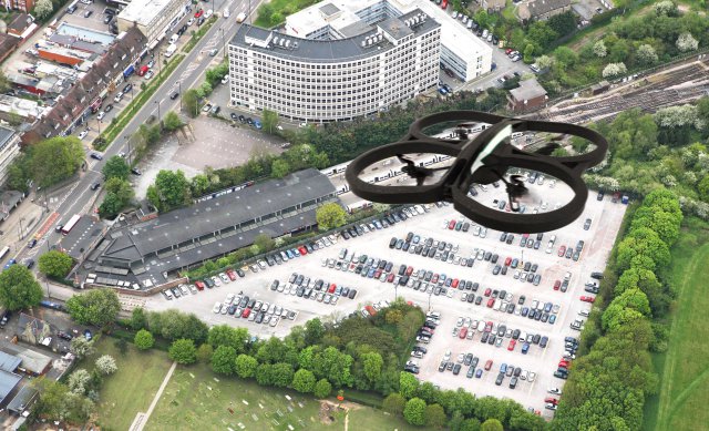
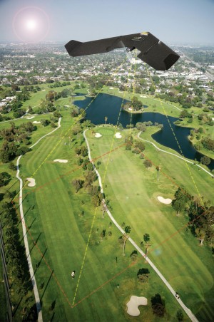
Aerial mapping companyBlueskyhas produced a prototype map of the UK showing where it may be unsafe or even illegal to fly Unmanned Aerial Vehicles (UAVs). Bluesky has combined an expertise in flight planning and 3D aerial mapping with various geographic datasets to come up with the concept of a UAV Flight Restriction Map.
The map is designed for commercial operators of UAVs and includes ‘No Fly Zones’, areas where further advice should be sought as well as areas where no restrictions on flying are currently in place.
“The UAV industry is rapidly expanding with new operators offering a wide range of services launching every day,” commented James Eddy, Technical Director at Leicestershire based Bluesky. “With nearly twenty years’ experience in planning large scale aerial surveys, combined with some of the most up to date and accurate geographic data and advanced processing techniques, we have been able to produce this prototype map. It is, however, designed just as a guide to where you can and cannot fly, so UAV operators should still check with the appropriate authorities.”
Currently operators of UAVs in the UK must comply with Civil Aviation Authority (CAA) regulations if they plan to undertake ‘aerial work’, while those equipped for data acquisition and or surveillance must obtain permission before ‘commencing a flight in a congested area or in proximity to people or property’. An overriding, all encompassing CAA Article also provides guidance in that a ‘person must not recklessly or negligently cause or permit an aircraft to endanger any person or property’, while other restrictions cover the dropping of articles or animals, minimum distances when flying near people or properties, and references to the Data Protection Act.
Bluesky’s UAV Flight Restriction Map is designed to provide a ‘first stop’ reference for commercial operators of UAVs in addition to CAA guidelines. The colour coded map uses a traffic light system to identify different zones: ‘No Fly Zones’ in red, areas close to no fly zones where further advice should be sought in amber, and ‘Free Fly’ zones in green. This easy to use resource takes into consideration population densities based on small scale postcode units, and congestion based on road location and type. The Bluesky UAV Restriction Map also considers the location and impact of aerial obstacles, such as overhead power lines, and restricted airspace including no fly zones around airports.
The launch of the prototype UAV Flight Restriction Map by Bluesky follows attempts around the world to develop control systems for commercial UAV, UAS (Unmanned Aerial System) or drone deployments. NASA, working with the Federal Aviation Administration (FAA) with input from government, industry and academic partners, has recently announced plans to develop a UAS Traffic Management System (UTM) that will keep track of and communicate important information to UAS operators in real time.
ECA wants EASA to Prioritise Safety in UAV Regulations
The European Cockpit Association (ECA) haspublished a paper calling for regulations on unmanned air vehicles proposed by EASA to focus on the safety of people and manned aviation, and not the rights of recreational operators to fly such Aircraft.
First outlined in March 2015, the safety authority’s proposal suggests that the operation of UAVs in civil airspace be proportionate to the risk each poses, and recommends they be divided into three categories – open, specific and certificated – that take into consideration the variety of types and operations.
According to the proposed regulations, those aircraft categorised as “open” would not require authorisation from an aviation authority, but would need to stay within defined boundaries.
While the ECA acknowledges that UAVs have potential benefits, it notes that it is “absolutely critical that the technology is introduced safely, in particular with regard to existing manned aviation”.
Given the damage just one accident involving UAVs in which people are harmed would do to the development of the industry, “thought-out, effective, efficient regulation” is required, the association says.
“Most drones in the open category will be mass-market consumer products [and] may have significantly different capabilities in a few years, and any regulation needs to deal with this,” the ECA says in its position paper on the proposed regulations. “This cannot happen without proper risk assessment, especially of mid-air collision risk.”
It adds that scientific and engineering research on the effects of unmanned and manned aircraft collision is lacking, so this “must be conducted as a matter of urgency”.
The ECA proposes a number of mandated requirements for “open” UAVs, including: a maximum distance from the pilot of 500m (1,640ft) horizontally and 164ft in height; automatic avoidance of restricted areas; automatic recovery; a 500g weight limit; speed limitations; visibility standards for recognition and avoidance; and marking and registration of the UAV.
It adds that a UAV should be obliged to avoid manned aircraft; be operated within visual line of sight and not near third parties without consent; and stay away from manned aircraft sites. Pilots should also be sufficiently trained, and the UAVs that fall into the open category should only be operated for recreational purposes, says the ECA. This would leave the specific and certificated categories for commercial flight.
A draft regulatory framework is to be presented to the European Commission by EASA by the end of 2015. This will be followed soon after by the safety authority’s presentation of a final regulatory proposal for the open category.
Germany Gets 1st H135 Configured for Offshore Hoist
AirbusHelicopters has delivered the first H135 configured for offshore hoisting duties to Germany-based operator HTM Travel Munich GmbH. The H135 fulfills all requirements for offshore missions, with equipment that includes a rescue hoist, an external life raft system, Helicopter Emergency Egress Lighting, Automatically Deployable ELT (Emergency Locator Transmitter), 3-Axis-Autopilot, Weather Radar, Underwater Locator Beacon and Emergency Floatation System certified for Sea State 6. HTM will use the helicopter for the maintenance of wind turbines located off the German coast in the North Sea, and has also contracted with 10 wind farms and customers like DONG, EWE, EON, Siemens, DOTI, ADWEN and Senvion.
MH370 search: Reunion debris 'very likely' part of plane
23 minutes ago
From the sectionAsia
Media caption
It is "very likely" debris found on the Indian Ocean island of Reunion is that of the missing flight MH370, a top Australian official has told the BBC.
Martin Dolan, who heads Australia's search efforts, also said the operation was continuing "in the right place" in the southern part of the ocean.
The wreckage, said to be a wing part, is to be flown to France for analysis.
The Malaysia Airlines flight - a Boeing 777 travelling from Kuala Lumpur to Beijing - vanished in March 2014.
There were 239 passengers and crew on board the plane when it went missing.
French examination
The debris washed up on Reunion island on Wednesday, some 4,000km (2,500 miles) from the area where MH370 is thought to have gone down.
Mr Dolan, who heads the Australian Transport Safety Bureau, told the BBC that he was "increasingly confident that the wreckage... is associated with a 777 aircraft".
Media caption
Aviation experts who have studied photos of the debris say it resembles a flaperon - a moving part of the wing surface - from a Boeing 777.
"There is no other recorded case of a flaperon being lost from a Boeing 777," Mr Dolan said.
"We are confident we have the quality of the search to cover that area and find the missing aircraft," he added.
Guided by signals from the plane that were detected by satellite, authorities believe it went down in the southern Indian Ocean.
However, no physical evidence of this has ever been found and in January Malaysian authorities declared that all on board were presumed dead.
Location of a flaperon on a Boeing 777
Earlier, Australian officials and Malaysian Prime Minister Najib Razak said the location of the debris was consistent with drift analysis provided to investigators.
The wreckage is expected to be flown to the French city of Toulouse later on Friday. French media quote officials as saying it will be examined by experts it next week.
The BBC's Chris Bockman in Toulouse says aviation authorities have a huge hangar facility to store and study wreckage - as they did with the Air France airliner that crashed on its way from Brazil to Paris in 2009.
BBC transport correspondent Richard Westcott says the object may have a data tag with a serial number that could be directly traceable to MH370. Even if there is no tag, it should have a traceable manufacturer's stamp, he adds.
Media caption
Simulation of where debris in search area could end up
Norwegian P-3B at NAS Moffett in 1969 With the blimp hangar still in one piece - Picture: Per Gram
Amazon, NASA and what's holding the drone economy
back
The flat, sprawling expanse that once served as Silicon Valley's federal
airfield - and has since been leased to Google for the company's own aerospace
and robotics research - provided a fitting backdrop this week for a meeting of
the aviation and high-tech sectors.
In a far-flung corner of the guarded campus at Moffett Field, past the
retro military commissary and other relics from facility's heyday as a hub for
government-powered space exploration, a series of white tents have been arranged
behind a high barbed wire fence.
Despite the low-tech ambiance, the meeting convened by NASA and the
Association for Unmanned Vehicle Systems International has a decidedly high-tech
focus: charting a more coherent path forward on the deployment of drone
technology.
"This is really a call to action," said Gur Kimchi, vice president and
co-founder of Amazon Prime Air. "We need to come together as an industry."
Det har rent en del vann i havet siden sist jeg satt i venstresetet i maskinen. Det var et veldig interessant besøk jeg hadde på 333 skvadron, nå del av 133 Luftving, den 23. juli. Jeg fikk en oppdatering på maskinen og fant at det i cockpit var veldig få endringer fra B-modellen jeg fløy.Ny ADI og HSI var det, men de dominerende motorinstrumentene var de samme. GPS var kommet på styrmannens sidekonsoll og varsling for trusler koplet til flares var der. Plottebordet var elektronisk. Kabinen bar preg av at den er modulær, altså lett å ominnrede/modifisere. Flyene har fått nye vinger og holder i 20 år til.
Skvadronen var preget av at den var veldig sterkt beskåret fra da jeg var skipper på det 8. crewet. Jeg vil føle ubehag ved å fortelle mer i detaljer om dette, men det er åpenbart for undertegnede at skvadronen lider under gjentatte kutt.
Relokaliseringsspøkelset går i gangene og legger også en klam hånd over investeringslysten i kommunen. Gatene i Andenes bærer preg av nedgangstider selv om det er aktivitet i havna og at deler av Storgata har blitt miljøgate. Flere butikker har lagt inn årene. Mange av husene i Merket I og Merket II er fraflyttet.
"Noen" ønsker at P-8 Poseidon skal overta rollen til P-3. Vel, undertegnede har fått detaljkunnskap om P-8 gjennom besøk hos Boeing Renton hvor den bygges og annet. Jeg tror at vårt Forsvar er best tjent med å beholde P-3 i 10 år til, minst, og å opprettholde samt styrke basen på Andøya.