SpaceX Deploys Airplane Trackers in 'Delicate
Choreography'

MCLEAN, VIRGINIA - A million
emotions were going through Matt Desch. He felt as if he were awaiting the
arrival of a child. He was actually "birthing" 10 of his company's communication
satellites into orbit, part of an eventual replacement of 66
satellites.
"One of the most complicated technical feats in the aerospace
industry," he said.
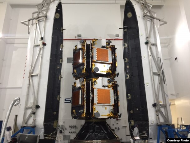
A SpaceX Falcon 9 rocket carried the 10 Iridium satellites aloft
Saturday. When the rocket was halfway around Earth and in the proper orbit, it
sent Desch's "babies" off one by one, every 90 seconds, into space. They were to
unfold their solar panels and reorient themselves with the stars and the
horizon.
Desch said the 850-kilogram satellites, the size of a Mini Cooper,
would start looking for antennas and begin communicating with Iridium's ground
station in Norway, which will transmit the data to Virginia.
And eventually, the payload on board the satellites could
revolutionize how airplanes fly.
'Landmark moment'
"Today, Iridium launches a new era in the history of our company and
a new era in space as we start to deliver the next generation of satellite
communications," Desch said. "We have been working endless hours for the last
eight years to get to this day." He called the successful launch of the
satellites into low-Earth orbit "a fulfilling moment."
"Today is a landmark moment in history for global air traffic
surveillance, air traffic safety and the aviation industry as a whole," said Don
Thoma, CEO of Aireon, the company that developed the system inside the payload.
"This successful first launch brings us one step closer to changing the way the
world flies by enabling the ability to track aircraft anywhere on the
planet."
Over the next three months, the engineers will position the new
satellites and perform a delicate choreography in a slot swap with the old
satellites.
The satellites travel at 27,000 kph. Each replacement must be
completed while the satellites are moving, without any noticeable disruption to
service. Sometime in 2018, all 66 satellites will have been exchanged for new,
technologically improved versions.
No more 'black zones'
Currently, 70 percent of the world's airspace is without real-time
surveillance because of rough terrain, deserts or vast oceans. The technology on
the new satellites makes airplanes trackable over the entire Earth, including
those black zones.
No one can currently pinpoint a plane in those areas - even on a
flight over the Atlantic from the United States to Europe - except the pilot and
the passengers. "You look at the screen on the back of the seat and you see the
map and you recognize where you are. But air traffic control [only] knows
roughly where you are," Thoma said.
The new technology is aimed at eliminating incidents like the
aftermath of Malaysia Airlines Flight MH370. The plane disappeared over the
ocean nearly three years ago while flying from Kuala Lumpur, Malaysia, to
Beijing, China. The body of the plane and the remains of the 239 people on board
have not been found, despite an extensive underwater search of the Indian Ocean.
Only a piece of debris was discovered off Reunion Island.
Prior to that in 2009, Air France 447 crashed into the Atlantic Ocean
while flying from Rio de Janeiro to Paris. The flight recorders were not
recovered until two years later.
The more recent mystery surrounding MH370 prompted the industry to
re-examine airplane tracking standards. National and international aviation
agencies have implemented rules and recommendations to make real-time tracking
possible.
Currently, U.S. pilots report their positions every 15 minutes.
Internationally, pilots will be required to do that by the end of next year. A
new rule, eased in by 2021 by the United Nations' International Civil Aviation
Organization (ICAO), makes it mandatory for planes under distress to transmit a
location report every minute.
Automatic signaling
Airplanes will do this through a surveillance technology called
automatic dependent surveillance-broadcast (ADS-B.) The ADS-B will transmit the
plane's coordinates every minute to a receiver, like Aireon's system in the
sky.
The ADS-B equipment is not mandatory in all planes until 2020, two
years after the receivers are operational. VOA asked about the delay during a
media conference call with Federal Aviation Administrator Michael Huerta. He
said the cost-benefit ratio was not justifiable, since the tracking system would
benefit only "a small number of flights."
But Aireon says the system affects thousands of flights daily and the
industry as a whole, since airlines will be able to create more direct routes
without avoiding traditional dead zones.
Passengers will benefit from more efficient and more frequent
flights. CEO Thoma says airlines will save millions of dollars in fuel costs,
and the reduced fuel burn will cut carbon emissions, thus contributing less to
global warming.
Some new planes already are equipped with the technology and are
awaiting 2018, when Iridium satellites begin their tracking.
The Iridium satellite constellation is not the only group poised to
implement the technology. Marco Caceres, a senior space analyst at the Fairfax
Teal Group, an aerospace and defense firm, says Global Star also offers a
lower-orbit satellite system, but Iridium's system is larger and will be the
first of its size to be operational.
"It may be that Iridium may be able to be the one of the early
pioneers of this, but this is going to be the wave of the future for other
satellite systems as well," Caceres said.


Ingen kommentarer:
Legg inn en kommentar
Merk: Bare medlemmer av denne bloggen kan legge inn en kommentar.